


How climate change sparked a multistate battle over the Colorado River.
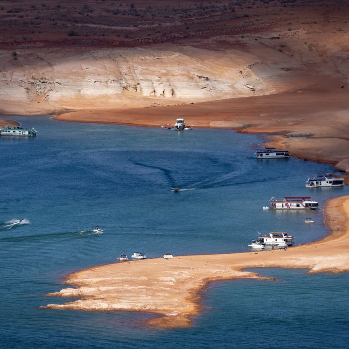
Photo: David McNew/Getty Images
Photo: David McNew/Getty Images
The Colorado River’s 1,450-mile run begins amid the snowy pinnacles of the Rocky Mountains and ends in the subtropical waters of the Gulf of California. Over the millions of years the river has been running this course, it has gradually carved through the Southwest’s crimson limestone and shale to create a succession of unimaginably vast canyons: Ruby, Cataract, Marble, and Grand. The writer Marc Reisner described the Colorado as the “American Nile.” The Hualapai call it Hakataya, “the backbone.”
Starting in the early 20th century, much of the Colorado’s natural majesty was corralled into a system of reservoirs, canals, and dams that now provides drinking water for 40 million people, irrigation for 5 million acres of farmland, and sufficient power to light up a city the size of Houston. Not so long ago, there was more than enough rainfall to keep this vast waterworks humming. The 1990s were unusually wet, allowing the Colorado to fill its two sprawling reservoirs, Lake Mead and Lake Powell, to 95 percent of capacity. By 2000, more than 17 trillion gallons of water were sloshing around in the reservoirs — more than enough to supply every household in the United States for a year.
Then the drought arrived. And never left. After the driest two-decade stretch in 12 centuries, both Mead and Powell fell below one-third of their capacity last year, throwing the Southwest into crisis. On January 1, mandatory cuts went into effect for the first time, forcing farmers in Arizona and the utility that provides water to metropolitan Las Vegas’s 2.3 million customers to limit their uptake from Lake Mead. Even with those cuts, Bill Hasencamp, a water manager from Southern California, says, “The reservoir is still going down, and it will stay low for the next several years. I don’t think we’ll ever not have a shortage going forward.”
If Hasencamp is right — and most scientists agree that America’s deserts will only get drier as the climate crisis worsens — that means he and other officials in the region have their work cut out for them to ensure that the Southwest stays hydrated. The Colorado River is currently governed by a set of operating guidelines that went into effect in 2007, the latest in a long line of agreements that began with the original Colorado River Compact in 1922. But that framework is set to expire in 2026, giving officials in the seven states through which the Colorado and its tributaries flow — along with their peers in Mexico and the 29 tribes whose ancestors have depended on the river for millennia — an alarmingly narrow window to come to a consensus on how to share a river that’s already flowing with one-fifth less water than it did in the 20th century.
The Southwest’s water managers have been working feverishly this spring just to prop up the system until formal negotiations can begin next winter. In March, the water level of Lake Powell declined below a threshold at which the Glen Canyon Dam’s ability to generate power becomes threatened, and the Bureau of Reclamation, the federal agency that oversees the West’s water infrastructure, is working with the states above Lake Powell to divert more water to keep its dam operational. Meanwhile, the states around Lake Mead have been hashing out the details of a plan to voluntarily curtail their use to prevent even more dramatic cuts to Arizona and Nevada from going into effect next year.
Poor hydrology isn’t the only thing on the water managers’ minds: They’re also contending with the yawning cultural and political chasm between the region’s urban and rural interests as well as questions about who should suffer the most aggressive cuts and how to better engage Indigenous communities that have historically been cut out of the dealmaking. All of that makes the Southwest’s deliberations over the Colorado River a window into how climate change is putting pressure on divisions embedded throughout American society.
Pat Tyrrell, Wyoming’s former state engineer, says if the states fail to reach an accord, “we’re looking at 20, 30 years in the court system.” That would be a nightmare scenario given how disastrous the past two decades have been for the river. Falling back on the existing framework of western law could result in hundreds of thousands of people being stranded without water or electricity — or, as John Entsminger of the Southern Nevada Water Authority puts it, “multiple Katrina-level events across southwestern cities.” The negotiations, then, represent the first major test of the American political system’s ability to collaboratively adapt to climate change. “I think the states feel a strong interest in working this thing through among ourselves so that we don’t end up there,” says Tyrrell. “We can’t end up there.”
Although the Colorado River is a single water system, the 1922 Colorado River Compact artificially divided the watershed in two. California, Nevada, and Arizona were designated the Lower Basin, while Wyoming, Colorado, New Mexico, and Utah were labeled the Upper Basin. Each group was awarded half of the river’s water, and a series of ensuing agreements divided that pot between the states in each basin according to their population and seniority. Mexico’s right to the Colorado took until 1944 to be enshrined, while each of the region’s 29 tribes had to fight for its entitlements in court. Every water allocation in the multitude of treaties and settlements that branch out from the original compact is quantified using the agricultural unit of an acre-foot, the amount of water it takes to flood an acre of land to a depth of one foot (a helpful rule of thumb is that one acre-foot is enough water to supply three households in the Southwest for one year).
The fundamental flaw of this compact is that it was signed at a time of unprecedented rain and snowfall in the basin, which led its original framers to assume that 15 million acre-feet of water flowed through the Colorado every year. In the 21st century, the annual average flow has been closer to 12 million acre-feet, even as much more continues to be diverted from Lake Mead and Lake Powell every year — that discrepancy helps to explain how the reservoirs have emptied so quickly. The other culprit is climate change.
In March, Bradley Udall, a water and climate researcher at Colorado State University, gave a presentation at the University of Utah’s Wallace Stegner Center that laid out several models for how much drier the basin could become by 2050, including an especially frightening forecast that the river may end up carrying 40 percent less water than it averaged during the 20th century. “There’s just a lot of worrisome signs here that these flows are going to go lower,” Udall says. Tanya Trujillo, who, as the assistant secretary for water and science at the Department of the Interior, is effectively the federal government’s top water official, agre